
Climate finance: Canadian successes
Canadian geomatics showcased in fight against climate change
As the global effects of climate change become more and more complex, the need for accurate, reliable and timely information to help inform decision making has been brought to the forefront. Many developing countries are being particularly hard hit by the impacts of climate change, including coastal erosion, rising sea levels and shifting rainfall patterns, bringing increased potential for floods and droughts.
Geomatics is the branch of science that deals with the collection, analysis and interpretation of data relating to the earth’s surface. Geomatics, remote sensing technologies and surveying all play a key role in planning or adapting land use. These technologies are also important to help better understand the evolution of ecosystems and their impacts on human communities, settlements and the environment. Increasingly, highly refined geomatics applications are being used to plan for energy investments—namely in solar energy—to strengthen the resilience of cities and to redraw or rehabilitate roads in difficult terrains. The increased accessibility of high-resolution, open data sets is now more widespread than ever before, which has democratized access to these advanced technologies in countries that could not access them previously.
Examples of Canadian geomatics applications for developing markets
Canadian geomatics leader Effigis has worked on a number of climate change-related initiatives, including a recent project in Vietnam, funded by the World Bank, which sought an analysis of the potential for installing rooftop solar systems in the country’s largest cities. The work required providing data on the number and type of rooftops on which solar photovoltaics could be installed effectively. This data then informed future investments by the World Bank and the Government of Vietnam. For this initiative, Effigis worked with satellite operators to acquire high-resolution data, characterized some 1.5 million rooftops using advanced artificial-intelligence techniques, performed quality checks and interpretation of results, conducted field assessments to validate results and developed a web platform to disseminate the results, in addition to providing training and capacity building for local authorities.
In June 2016, GHGSat launched the world’s first high-resolution satellite capable of measuring greenhouse gas (CO2 and CH4) emissions from any industrial facility in the world. GHGSat is using this unique satellite and its patented technology to provide greenhouse-gas-emissions monitoring data and services globally, with better accuracy and at a fraction of the cost of comparable alternatives. The second satellite in GHGSat’s constellation is scheduled to be launched in early 2019, with many more to follow shortly thereafter.
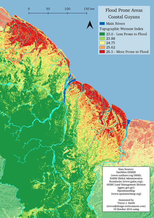
DE Design + Environment design and consulting group recently conducted work to support the governments of Caribbean countries in developing agricultural risk maps. These maps highlighted potential climate change impacts in terms of rainfall patterns and storm activity using open data. They are considered specialists in integrated environmental analysis and design and have worked across the Caribbean and worldwide on various mandates, helping governments, companies and other organizations become more resilient to environmental change.
Key geomatics markets
According to Research and Markets, the global remote-sensing technologies market is likely to reach approximately US$19.3 billion by 2025. Europe currently leads the market, with Asian countries not far behind. The geographic information system (GIS) market in the Middle East and Africa is estimated to be worth $1.44 billion in the year 2017 and is to reach $4.75 billion in the year 2025. Technologies such as LiDAR, satellite imagery acquisition and interpretation, and marine sensing are increasingly in high demand, especially for their ability to help address climate change.
Other areas of application
Forests are quickly becoming tangible assets in the fight against climate change, yet monitoring illegal deforestation is an expensive undertaking. Therefore, countries are turning to remote sensing technologies to provide near real-time monitoring. Forest-rich countries, such as Brazil, Suriname and the Democratic Republic of Congo, are using remote sensing and GIS technologies, and that number is expected to grow as carbon finance becomes more readily available at national and international levels. For example, India has recently added forest cover among the criteria for allocating tax revenues to states, creating a powerful incentive for the maintenance of forest health and longevity.
Other sectors of interest for developing countries in the broad field of “earth observation” include applications related to meteorology, hydrology, early warning systems and climate change modelling. Because developing countries are more likely to suffer higher impacts from climate extremes, many adaptation initiatives now include measures to increase observation and prediction capacity.
Where to find opportunities
Geomatics is now a feature in a number of climate change projects. Opportunities include the design and provision of software, equipment and parts, as well as the interpretation services, training and capacity building required for developing countries to successfully use and operate the technology after the project ends. These opportunities can be sourced through international financial institutions.
Many multilateral development banks (MDBs) open their tendering processes to international suppliers and often post detailed general procurement plans on their websites. Specific opportunities for geomatics projects, as well as other climate-related sectors, are likely to be advertised directly on the MDB websites or through the tendering portals listed in the tools section below. Setting up a website monitoring function is advised.
For smaller-sized procurements, advertisements will sometimes be posted exclusively in-country in local newspapers, the official gazette or government websites. MDBs issue project-based requests for proposals, as well as for corporate procurement. Registration as a vendor with MDBs is free; however, some eligibility requirements apply.
Most MDBs have dedicated private-sector lending windows, or distinct organizational entities, through which they provide financial lending directly to the private sector. This is offered through a variety of financial products, such as debt financing, equity investment, guarantees and/or grants.
In addition to MDBs, many countries have bilateral development agencies that open their tendering processes to international suppliers. This means that Canadian companies are eligible to bid on projects funded by these agencies. Some bilateral development banks or funds also provide financing directly to private industry for development projects.
Tools
Tender aggregation portals:
Climate Technology Centre and Network (CTCN)
Working with multilateral development banks or international financial institutions:
Working with bilateral agencies:
Connect with us
The Canadian Trade Commissioner Service has more than 160 offices around the world with dedicated officers available to assist you with international trade activities. Specialized assistance is available for climate finance.